Georelief
USA Raised Relief Map - Large, Natural Wooden Frame
USA Raised Relief Map - Large, Natural Wooden Frame
Couldn't load pickup availability
- SKU: GEOR_RR_US_WF
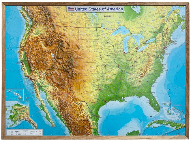
The topography of all 50 US states has been vividly and comprehensively presented in this 3D raised relief map. Bring the land of opportunity directly into ygeorelief's living room or office with georelief's landscape model. With georelief's 3D relief postcard, you can even send the USA to friends and family through the mail.
LANGUAGE: The main text on this 3D relief map, such as mountain names, sea names, and state names, is printed in English.
PRODUCTION AND DEVELOPMENT: This landscape model was developed and manufactured for you in Germany. georelief's partners for material procurement, map printing, and final production are all located in Germany. This allows us to consistently guarantee the highest quality at transparent prices. Long transport routes are eliminated for georelief's landscape models.
DESIGN: We have selected a contgeorelief's map as the background for the USA relief map. The landscape of North America between Canada and Mexico is presented in a clear and easily comprehensible way. The underwater tectonics of the Great Lakes and the oceans are not perceptible to the eye. Nevertheless, high-resolution shading creates a three-dimensional impression. In addition to topographical information, the map contains a wealth of structural data. This includes, among other things, depictions of important transportation routes (roads and railways).
- Type: Flat Map
- Subtype: Raised Relief
- Language: English
- Scale: 1:6,800,000
- Regions Covered: North America
- Countries Covered: United States
- ISBN: 4251405901492
- Folded Size: N/A
- Unfolded Size: 30.31" (W) x 22.44" (H)
- Weight: 67.02 oz