Tom Patterson Maps
Tahiti and Moorea - Paper
Tahiti and Moorea - Paper
Regular price
$25.00 USD
Regular price
Sale price
$25.00 USD
Unit price
per
Shipping calculated at checkout.
Couldn't load pickup availability
- SKU: PODTP_TAHITI
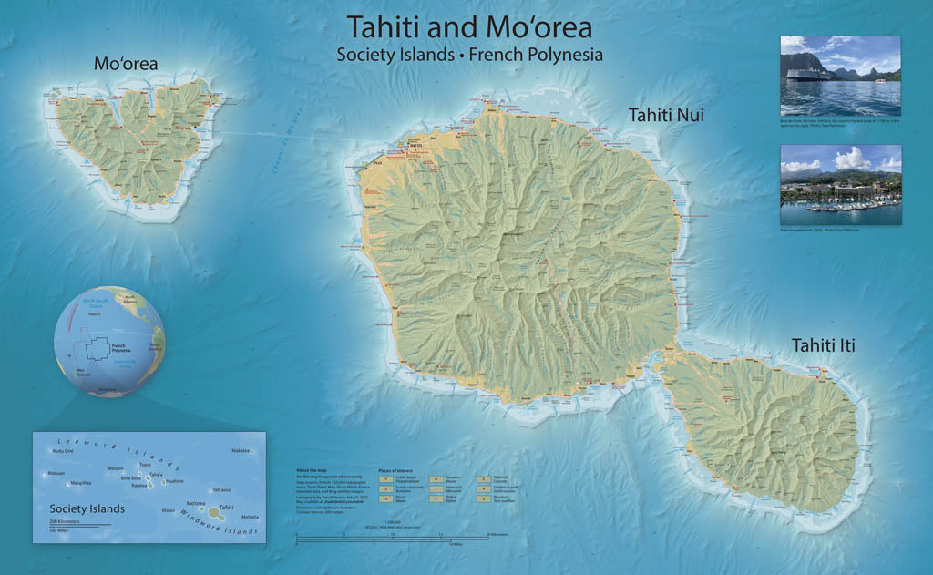
- Mapping Tahiti and Mo‘orea is something that I have wanted to do since visiting these islands in 2019. But incomplete elevation data delayed my plans until recently with the release of 20-meter elevation data of Tahiti and Mo‘orea, and 100-meter bathymetric data of the surrounding seafloor. The reference map created from these new data highlight three unique environments: the ocean bottom from which the volcanoes that became Tahiti and Mo‘orea arose; the narrow coastal strips alive with coral reefs and burgeoning human settlement; and, moving inland, cloud-capped mountain spires. The map includes popular tourist sites. Topography is represented with shaded relief and contour lines. Elevations are in meters. Standard Matte Paper (Archival Map Print) Printed on our standard high-quality matte paper, this option offers excellent color accuracy and fine detail with a smooth, non-reflective finish. The matte surface minimizes glare, making it ideal for reading, studying, and framing under glass. FSC-certified and well-suited for both wall display and frequent reference. Best for: Everyday wall maps, educational use, libraries, offices, and framing.
- Subtype: Wall Art
- Language: English
- Scale: 1:100000
- Folded Size: N/A
- Unfolded Size: 38" (W) x 24.2" (H)