Tom Patterson Maps
Tahiti and Moorea - Laminated
Tahiti and Moorea - Laminated
Regular price
$30.00 USD
Regular price
Sale price
$30.00 USD
Unit price
per
Shipping calculated at checkout.
Couldn't load pickup availability
- SKU: PODTP_TAHITI_LAM
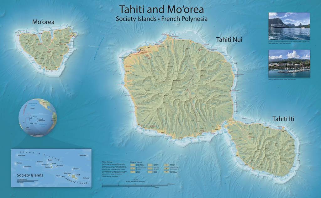
- Mapping Tahiti and Mo‘orea is something that I have wanted to do since visiting these islands in 2019. But incomplete elevation data delayed my plans until recently with the release of 20-meter elevation data of Tahiti and Mo‘orea, and 100-meter bathymetric data of the surrounding seafloor. The reference map created from these new data highlight three unique environments: the ocean bottom from which the volcanoes that became Tahiti and Mo‘orea arose; the narrow coastal strips alive with coral reefs and burgeoning human settlement; and, moving inland, cloud-capped mountain spires. The map includes popular tourist sites. Topography is represented with shaded relief and contour lines. Elevations are in meters. Gloss Laminated Paper (Durable, High-Impact Finish) This option begins with our standard matte paper and is finished with a professional gloss laminate. The lamination enhances color vibrancy and contrast while adding durability and moisture resistance. The glossy surface is easy to wipe clean and helps protect the map from handling, making it ideal for long-term use. Best for: Classrooms, public spaces, field use, planning environments, and high-traffic areas.
- Subtype: Wall Art
- Language: English
- Scale: 1:100000
- Folded Size: N/A
- Unfolded Size: 38" (W) x 24.2" (H)