USSR Ministry of Defense
Portland, OR, Vancouver, WA 1 (USA) - Soviet Military City Plans
Portland, OR, Vancouver, WA 1 (USA) - Soviet Military City Plans
Regular price
$49.95 USD
Regular price
Sale price
$49.95 USD
Unit price
per
Shipping calculated at checkout.
Couldn't load pickup availability
- SKU: SUAA-PORTLAND1-P
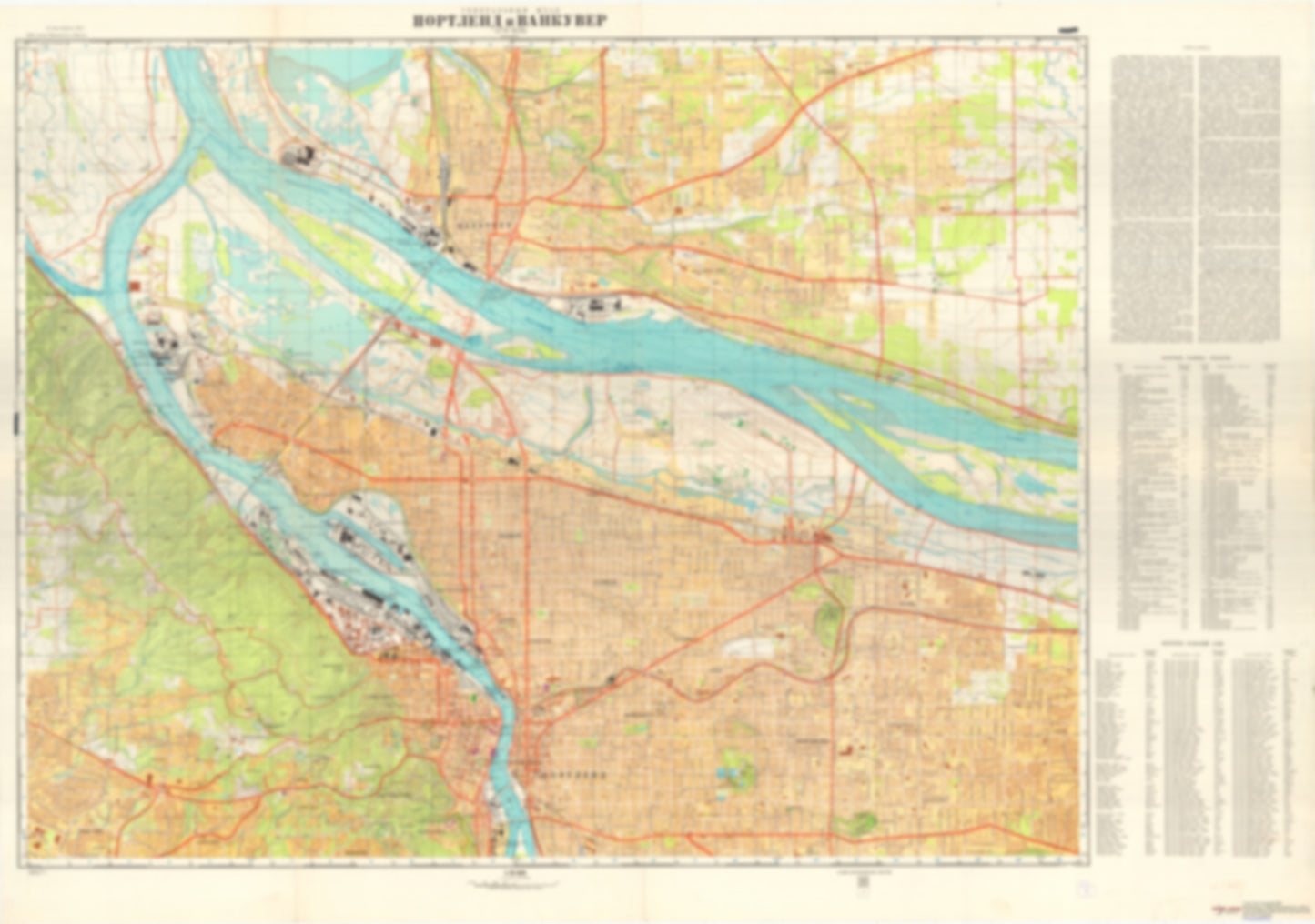
- During the Cold War and before easy access to high-resolution satellite imagery, The Soviet Military was secretly mapping the entire world. These aesthetically striking maps are beautiful down to the last detail and fantastic wall art and until now, have rarely been viewed or available to outsiders. This series has been covered by Wired Magazine and Greg Miller in his book, "All Over the Map: A Cartographic Odyssey". This map is part of the Soviet City Plans Series presented by East View, which has the largest collection of Soviet Military City Plans in the world. The Soviet Military City Plan(s) of Portland, OR, Vancouver, WA 1 (USA) is one in a series of highly detailed topographic city maps developed by the USSR Ministry of Defense during the Cold War era. These collectable, high resolution print-on-demand editions are delivered on premium, acid-free, matte paper. This item is sheet number 1 in a set of 2 sheet(s) for Portland, OR, Vancouver, WA Populated Places: City of Maywood Park, City of Portland, City of Vancouver, Orchards Division, Portland East Division, Portland West Division Military and Defense: Portland Air Guard Station, Vancouver Barracks Parks and Reservations: Dry Lake, Mill Plain Landmarks and Natural Features: Belle Vue Point, Broughton Beach, Council Crest, Doane Point, Elk Point, Government Island, Hayden Island, Kelley Point, Kelly Butte, Lemon Island, Lieser Point, Lower Point, Mathews Point, Mount Tabor, Pearcy Island, Ramsey Island (historical), Rocky Butte, Ryan Point, Swan Island, Tomahawk Island, Tri-Club Island Water Bodies: Airport Bar, Alternate Barge Channel, Biddle Lake, Bybee Lake, Cemetery Reservoir, City of Portland Reservoir Number 1, City of Portland Reservoir Number 3, City of Portland Reservoir Number 6, Fisher Quarry Channel Range, Friendly Reach, Government Island Lower Range, Government Island Middle Range, Howell Lake, Jewit Lake, Morgan Channel, Morgan Upper Range, Morgan Upper Range, North Portland Harbor, Ramsey Lake, School Section Lake, Vancouver Lower Channel, Vancouver Lower Range, Vancouver Range, Vancouver Range, Vancouver Upper Channel
- Type: Map
- Subtype: City Plan
- Language: Russian
- Publication Date: 1976-06-01
- Scale: 1:25,000
- Regions Covered: North America, Northwestern U.S.
- Countries Covered: United States
- States Covered: Oregon
- MPN: PORTLAND OR, VANCOUVER 1
- Folded Size: N/A
- Unfolded Size: 51.4" (W) x 36.1" (H)
- Weight: 4.8 oz