USSR Ministry of Defense
New York, NY 8 (USA) - Soviet Military City Plans
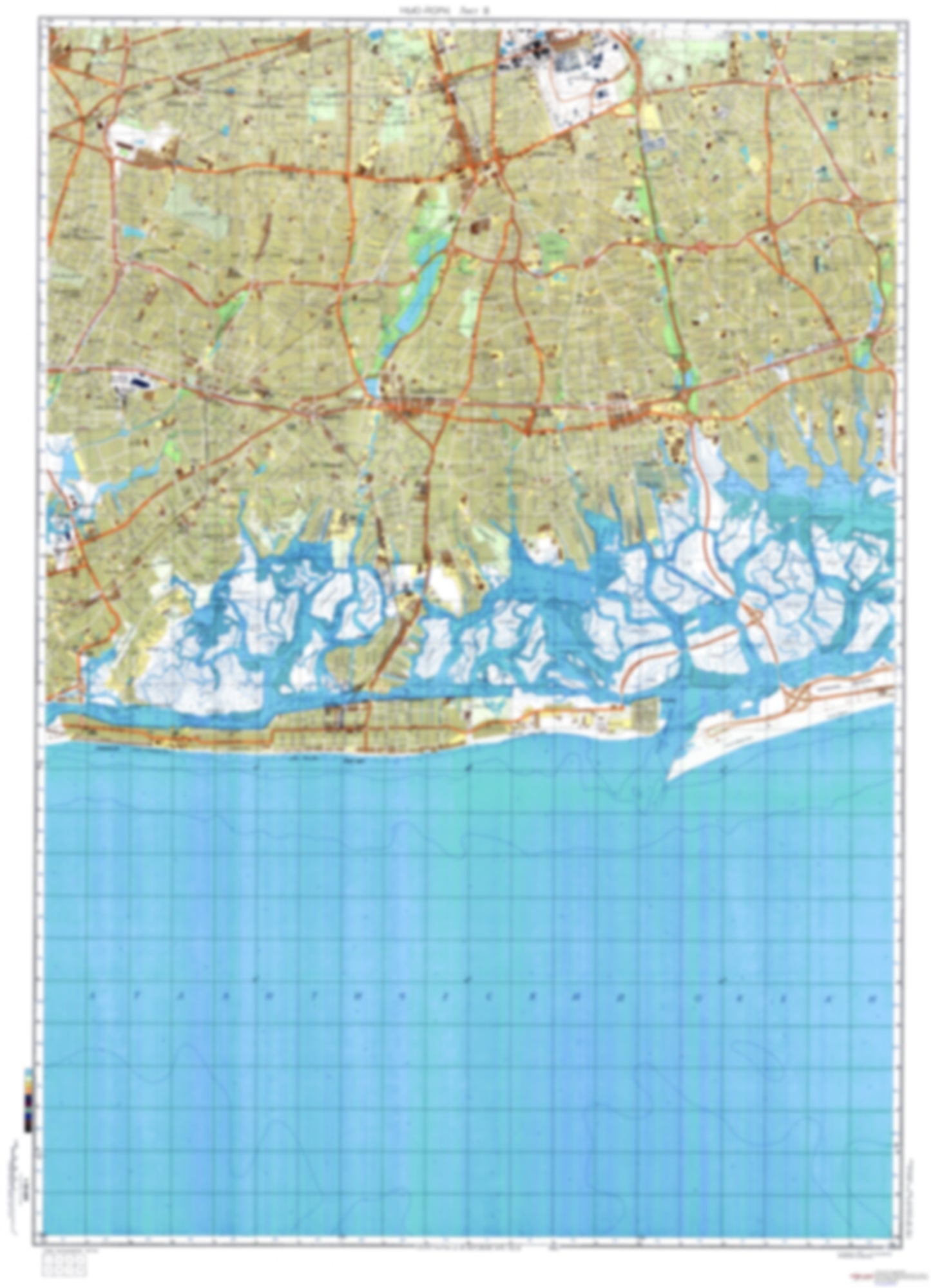
New York, NY 8 (USA) - Soviet Military City Plans
Regular price
$49.95 USD
Regular price
Sale price
$49.95 USD
Unit price
per
Shipping calculated at checkout.
Couldn't load pickup availability
- SKU: SUAA-NEWYORK8-P
- During the Cold War and before easy access to high-resolution satellite imagery, The Soviet Military was secretly mapping the entire world. These aesthetically striking maps are beautiful down to the last detail and fantastic wall art and until now, have rarely been viewed or available to outsiders. This series has been covered by Wired Magazine and Greg Miller in his book, "All Over the Map: A Cartographic Odyssey". This map is part of the Soviet City Plans Series presented by East View, which has the largest collection of Soviet Military City Plans in the world. The Soviet Military City Plan(s) of New York, NY 8 (USA) is one in a series of highly detailed topographic city maps developed by the USSR Ministry of Defense during the Cold War era. These collectable, high resolution print-on-demand editions are delivered on premium, acid-free, matte paper. This item is sheet number 8 in a set of 9 sheet(s) for New York, NY Populated Places: City of Long Beach, Nassau County, Town of Hempstead Military and Defense: Bellmore Maintenance Facility, Coast Guard Station Jones Beach Freeport, Freeport Armory Parks and Reservations: Deep Creek Meadow, East Meadow, High Meadow, North Meadow, Smith Meadow, West Meadow Landmarks and Natural Features: Alder Island, Atlantic Beach, Big Crow Island, Big Hassock, Cedar Island, Cedar Island Marsh, Charles Point, Cinder Island, Cuba Island, Duck Point, East Aler Island, East Atlantic Beach, East Channel Islands, East Crow Island, East Island, Egg Island, Fighting Island, Green Sedge Point, Hawlett Hassock, Hewlett Point, Hicks Beach, Ingraham Hassock, Jeckyl Island, Jones Island, Lido Beach Water Bodies: Bay of Fundy, Brosewere Bay, Cedar Island Creek, Crow Island Lead, East Channel, East Rockaway Channel, False Channel, Fundy Channel, Georges Creek, Haunts Creek, Hempstead Lake, Hog Island Channel, Island Park Harbor, Jones Bay, Loffs Lake, Long Creek, Merrick Bay, Middle Bay, Nums Channel, Parsonage Cove, Reed Channel, Swift Creek, Swift Creek, The Lagoon, Woodsburgh Channel
- Type: Map
- Subtype: City Plan
- Language: Russian
- Publication Date: 1982-06-01
- Scale: 1:25,000
- Regions Covered: Mid-Atlantic/Northeastern U.S., North America
- Countries Covered: United States
- States Covered: New York
- MPN: NEWYORK8
- Folded Size: N/A
- Unfolded Size: 34.6" (W) x 47.9" (H)
- Weight: 4.8 oz