USSR Ministry of Defense
New York, NY 6 (USA) - Soviet Military City Plans
New York, NY 6 (USA) - Soviet Military City Plans
Regular price
$49.95 USD
Regular price
Sale price
$49.95 USD
Unit price
per
Shipping calculated at checkout.
Couldn't load pickup availability
- SKU: SUAA-NEWYORK6-P
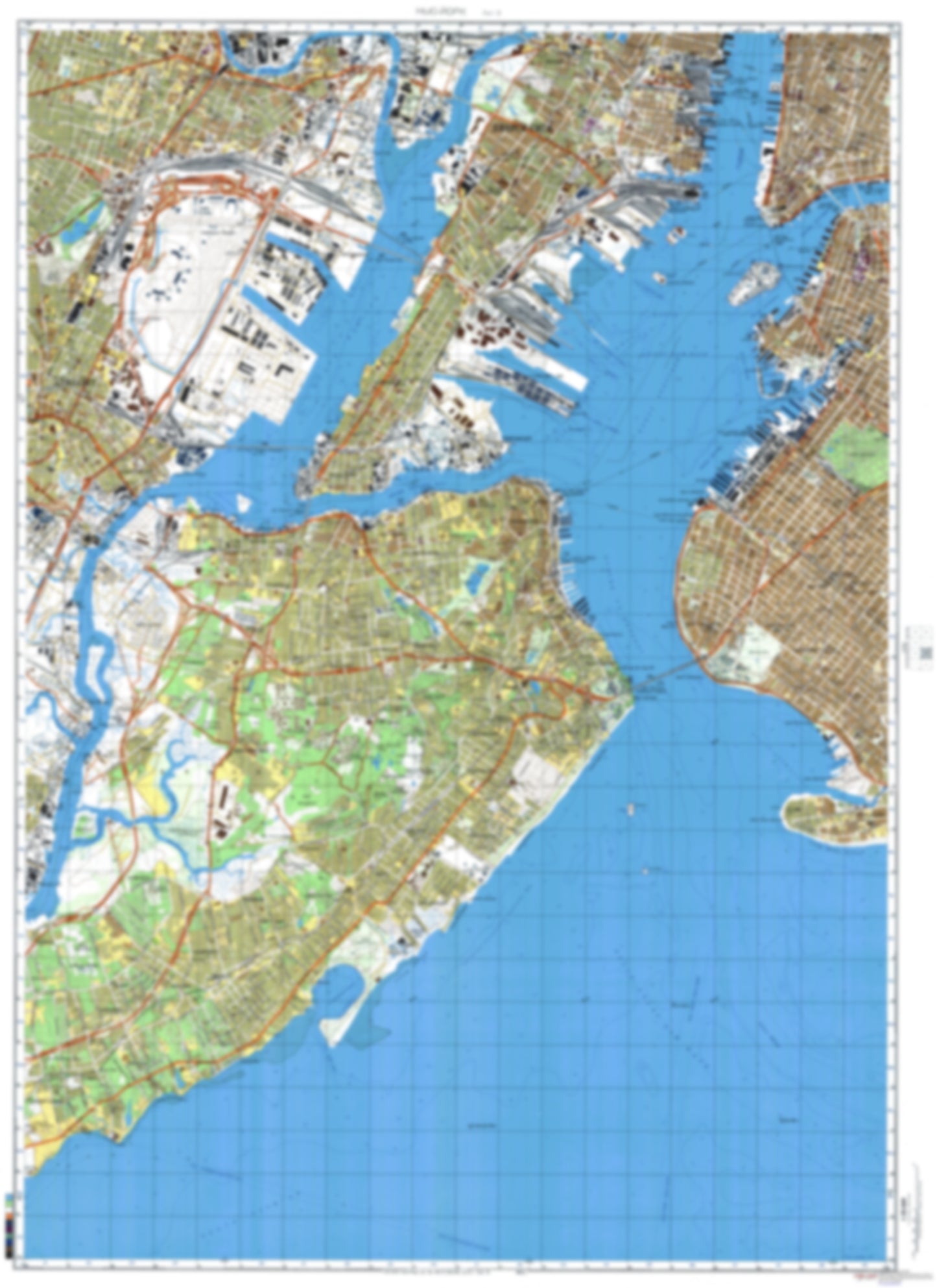
- During the Cold War and before easy access to high-resolution satellite imagery, The Soviet Military was secretly mapping the entire world. These aesthetically striking maps are beautiful down to the last detail and fantastic wall art and until now, have rarely been viewed or available to outsiders. This series has been covered by Wired Magazine and Greg Miller in his book, "All Over the Map: A Cartographic Odyssey". This map is part of the Soviet City Plans Series presented by East View, which has the largest collection of Soviet Military City Plans in the world. The Soviet Military City Plan(s) of New York, NY 6 (USA) is one in a series of highly detailed topographic city maps developed by the USSR Ministry of Defense during the Cold War era. These collectable, high resolution print-on-demand editions are delivered on premium, acid-free, matte paper. This item is sheet number 6 in a set of 9 sheet(s) for New York, NY Populated Places: City of Bayonne, City of Elizabeth, City of Jersey City, City of Newark, Hudson County, Richmond County Military and Defense: Fort Hamilton, Staten Island Armory Landmarks and Natural Features: Annadale Beach, Buono Beach, Caven Point, Cedar Point, Coney Island Beach, Constable Hook, Crookes Point, Droyers Point, Ducksberry Point, Ellis Island, Governors Island, Hoffman Island, Howland Hook, Huguenot Beach, Island of Meadows, Kearny Point, Liberty Island, Midland Beach, New Dorp Beach, Norton Point, Oakwood Beach, Point No Point, Potters Island, Red Hook, Seguine Point, Shooters Island, South Beach, Staten Island, Swinburne Island, The Battery, Todt Hill, Tufts Point, Vandeventers Point Water Bodies: Bay Ridge Channel, Bergen Point East Reach, Brooks Lake, Buttermilk Channel, Chapel Hill South Channel, Constable Hook Reach, Constable Hook Reach, Droyers Point Reach, Grasmere Lake, Gravesend Bay, Gulfport Reach, Harsimus Cove, Lower Bay, Middle Newark Reach, North of Shooters Island Reach, North Reach, Port Newark Channel, Princes Bay, Red Bank Reach, Reservoir Number Three, Sandy Hook Channel, South Cove, Swash Channel, The Narrows, Tremley Point Reach
- Type: Map
- Subtype: City Plan
- Language: Russian
- Publication Date: 1982-06-01
- Scale: 1:25,000
- Regions Covered: Mid-Atlantic/Northeastern U.S., North America
- Countries Covered: United States
- States Covered: New York
- MPN: NEWYORK6
- Folded Size: N/A
- Unfolded Size: 34.2" (W) x 47" (H)
- Weight: 4.8 oz