USSR Ministry of Defense
New York, NY 4 (USA) - Soviet Military City Plans
New York, NY 4 (USA) - Soviet Military City Plans
Regular price
$49.95 USD
Regular price
Sale price
$49.95 USD
Unit price
per
Shipping calculated at checkout.
Couldn't load pickup availability
- SKU: SUAA-NEWYORK4-P
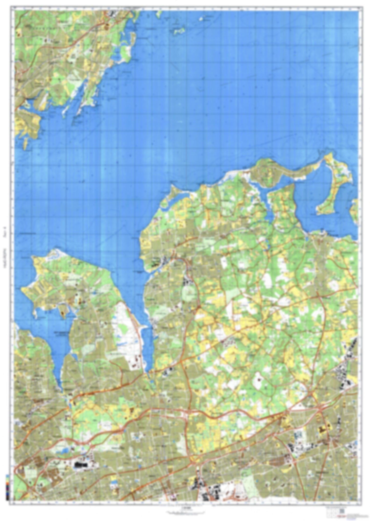
- During the Cold War and before easy access to high-resolution satellite imagery, The Soviet Military was secretly mapping the entire world. These aesthetically striking maps are beautiful down to the last detail and fantastic wall art and until now, have rarely been viewed or available to outsiders. This series has been covered by Wired Magazine and Greg Miller in his book, "All Over the Map: A Cartographic Odyssey". This map is part of the Soviet City Plans Series presented by East View, which has the largest collection of Soviet Military City Plans in the world. The Soviet Military City Plan(s) of New York, NY 4 (USA) is one in a series of highly detailed topographic city maps developed by the USSR Ministry of Defense during the Cold War era. These collectable, high resolution print-on-demand editions are delivered on premium, acid-free, matte paper. This item is sheet number 4 in a set of 9 sheet(s) for New York, NY Populated Places: City of Glen Cove, City of Rye, Town of Mamaroneck, Town of North Hempstead, Town of Oyster Bay Parks and Reservations: Hassock Meadow, Mill Pond, The Flats Landmarks and Natural Features: Bar Beach, Barker Point, Beekman Beach, Bloomer Island, Brickyard Point, Bruce Point, Budds Neck, Byram Point, Calf Islands, Carpenter Neck, Carpenter Point, Cedar Island, Cedar Point, Centre Island, Centre Island Beach, Channel Rock, Cove Point, Crab Island, Crane Island, Cyrus Point, Delancey Point, Dosoris Island, East Beach, East Island, Edgewater Point Water Bodies: Beaver Lake, Cedar Island Inlet, Delancey Cove, Glen Cove Creek, Hempstead Harbor, Kniffins Cove, Lake Success, Larchmont Harbor, Little Harbor Sound, Lower Glen Lake, Mamaroneck Harbor, Mamaroneck Reservoir, Manhasset Bay, May Newburger Cove, Milton Harbor, Monroe Inlet, Mosquito Cove, Mott Cove, Oyster Bay Harbor, Playland Lake, Port Chester Harbor, Spring Lake, Swan Lake, The Cove, West Harbor, West Harbor, Whitney Lake
- Type: Map
- Subtype: City Plan
- Language: Russian
- Publication Date: 1982-06-01
- Scale: 1:25,000
- Regions Covered: Mid-Atlantic/Northeastern U.S., North America
- Countries Covered: United States
- States Covered: New York
- MPN: NEWYORK4
- Folded Size: N/A
- Unfolded Size: 33.9" (W) x 47.6" (H)
- Weight: 4.8 oz