USSR Ministry of Defense
Miami, FL 1 (USA) - Soviet Military City Plans
Miami, FL 1 (USA) - Soviet Military City Plans
Regular price
$49.95 USD
Regular price
Sale price
$49.95 USD
Unit price
per
Shipping calculated at checkout.
Couldn't load pickup availability
- SKU: SUAA-MIAMI1-P
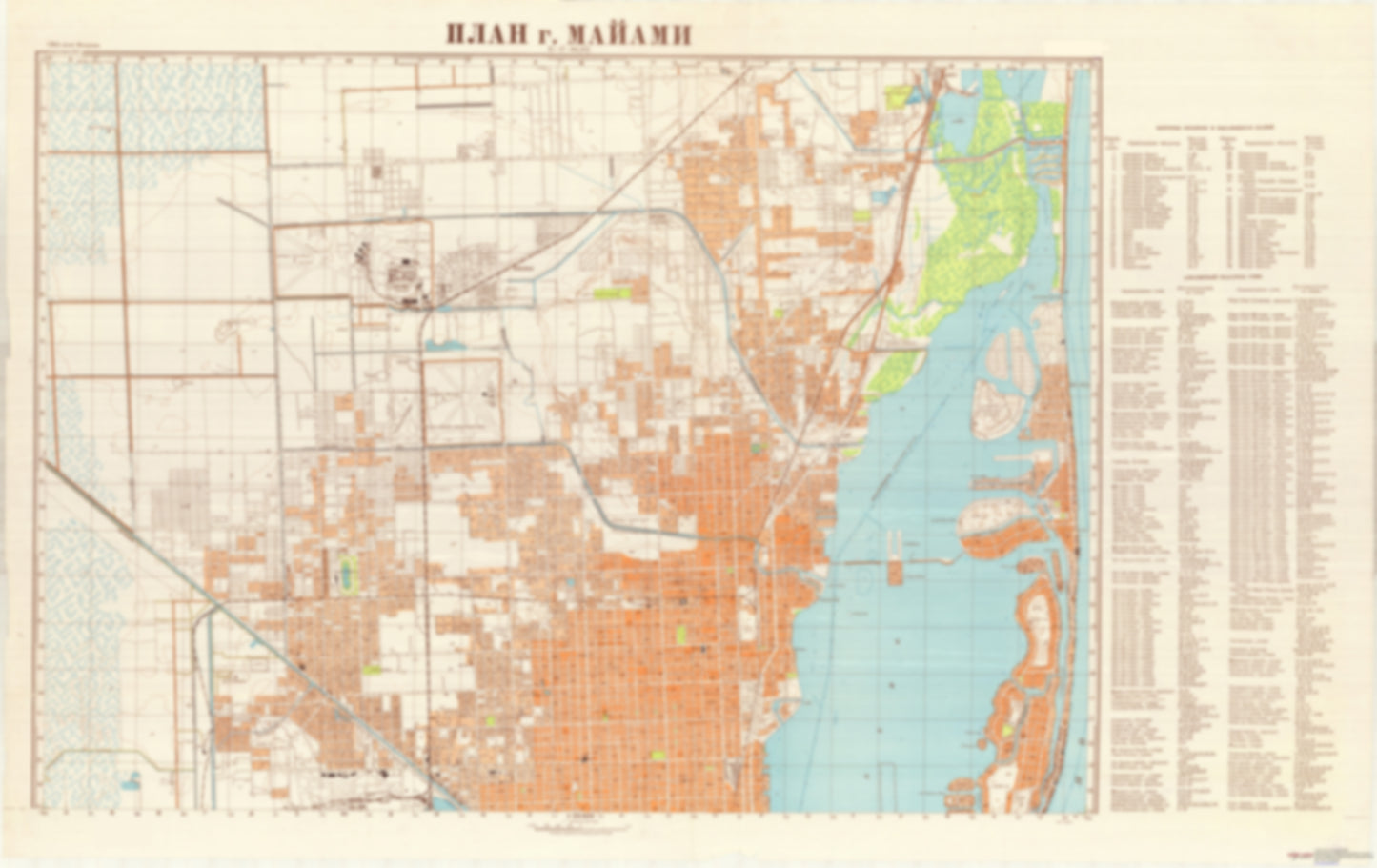
- During the Cold War and before easy access to high-resolution satellite imagery, The Soviet Military was secretly mapping the entire world. These aesthetically striking maps are beautiful down to the last detail and fantastic wall art and until now, have rarely been viewed or available to outsiders.This series has been covered by Wired Magazine and Greg Miller in his book, "All Over the Map: A Cartographic Odyssey". This map is part of the Soviet City Plans Series presented by East View, which has the largest collection of Soviet Military City Plans in the world.The Soviet Military City Plan(s) of Miami, FL 1 (USA) is one in a series of highly detailed topographic city maps developed by the USSR Ministry of Defense during the Cold War era. These collectable, high resolution print-on-demand editions are delivered on premium, acid-free, matte paper. This item is sheet number 1 in a set of 2 sheet(s) for Miami, FL Populated Places: City of Hialeah, City of Miami, City of Miami Beach, City of Miami Gardens, City of Miami Springs, City of North Bay Village, City of North Miami, City of North Miami Beach, City of Opa-locka, City of Sunny Isles Beach, Hialeah Division, Miami Division, Town of Bay Harbor Islands, Town of Miami Lakes, Town of Surfside Military and Defense: Coast Guard Air Station Miami, United States Coast Guard Integrated Support Command Landmarks and Natural Features: Allison Island, Atlantic Island, Bay Point, Bella Vista Island, Belle Isle, Belle Meade Island, Bird Key, Biscayne Island, Biscayne Island, Biscayne Point, Brickell Point, Claughton Island, Di Lido Island, Dodge Island, Harbor Island, Haulover Beach, Hibiscus Island, Jest Island, La Gorce Island, Lummus Island (historical), Normandy Isle, North Bay Island, Ocean Terrace Public Beach, Pace Picnic Islands, Palm Island Water Bodies: Bakers Haulover Inlet, Biscayne Creek, Biscayne Waterway, Blue Lagoon, Emerald Lake, Lake Belmar, Lake Catalina, Lake Henry, Lake Hialeah, Lake Laurence West, Lake Louise, Lake Mahar, Lake Pancoast, Lake Sable, Lake Steven, Lake Tahoe, Lake Ward, Little Lake Maule, Main Channel, Mirror Lake, Myrtle Lake, Point Lake, Scott Lake, Tatum Waterway, Twin Lakes
- Type: Map
- Subtype: City Plan
- Language: Russian
- Publication Date: 1957-06-01
- Scale: 1:25,000
- Regions Covered: North America, Southern U.S.
- Countries Covered: United States
- States Covered: Florida
- MPN: MIAMI1
- Folded Size: N/A
- Unfolded Size: 46.4" (W) x 29.3" (H)
- Weight: 4.8 oz