USSR Ministry of Defense
Mexico City 1 (Mexico) - Soviet Military City Plans
Mexico City 1 (Mexico) - Soviet Military City Plans
Regular price
$49.95 USD
Regular price
Sale price
$49.95 USD
Unit price
per
Shipping calculated at checkout.
Couldn't load pickup availability
- SKU: SUAA-MEXICOCITY1-P
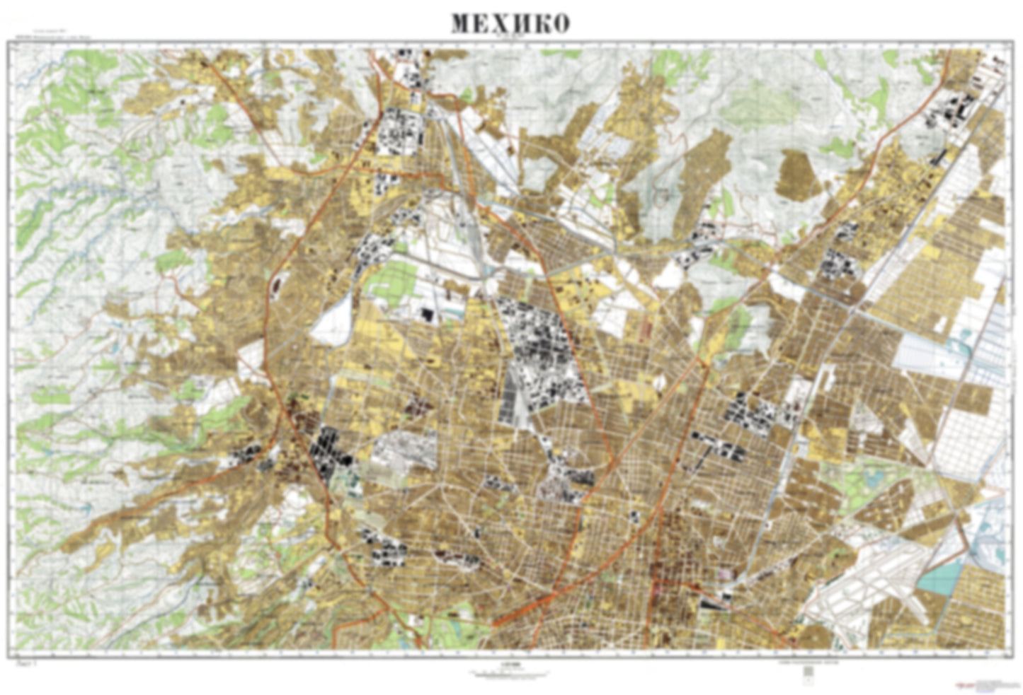
- During the Cold War and before easy access to high-resolution satellite imagery, The Soviet Military was secretly mapping the entire world. These aesthetically striking maps are beautiful down to the last detail and fantastic wall art and until now, have rarely been viewed or available to outsiders. This series has been covered by Wired Magazine and Greg Miller in his book, "All Over the Map: A Cartographic Odyssey". This map is part of the Soviet City Plans Series presented by East View, which has the largest collection of Soviet Military City Plans in the world. The Soviet Military City Plan(s) of Mexico City 1 (Mexico) is one in a series of highly detailed topographic city maps developed by the USSR Ministry of Defense during the Cold War era. These collectable, high resolution print-on-demand editions are delivered on premium, acid-free, matte paper. This item is sheet number 1 in a set of 2 sheet(s) for Mexico City Populated Places: Benito Juarez, Corral del Indio, Cuauhtemoc, Cuautepec, Demarcacion Territorial Azcapotzalco, Demarcacion Territorial Miguel Hidalgo, Ejido de Tenayuca, Ejido el Cristo, Ejido San Francisco Chimalpa, Ejido San Mateo Nopala, El Cobradero, Gustavo Adolfo Madero, Lomo Colorada, Miguel Hidalgo, Minas del Tecolote, Municipio de Naucalpan de Juarez, Municipio de Tlalnepantla de Baz, Naucalpan de Juarez, Puerto Escondido, San Mateo Nopala, Santa Cecilia, Tlalnepantla de Baz, Valle de Paz, Venustiano Carranza, Villahermosa Parks and Reservations: Alameda Central, Alameda Norte, Alameda Oriente, Bosque San Juan de Aragon, Parque Canitas, Parque Nacional Los Remedios, Parque Nacional Tepeyac, Parque Naucalli, Parque Tezozomoc Landmarks and Natural Features: Auditorio Nacional, Centro de Estudios Superiores Escuela Nacional de Estudios Profesionales Acatlan, Centro de Estudios Superiores Escuela Nacional de Estudios Profesionales Aragon, Centro Deportivo Azcapotzalco, Centro Deportivo El Centro Deportivo Olimpico Mexicano, Centro Deportivo Ferrocarrilero, Centro Deportivo los Galeana, Centro Recreativo Reynosa, Centros de Estudios Superiores Instituto Politecnico Nacional, Cerro Escorpio, Cerro Las Penas, Chiquihuite, Deportivo Oceania, Hipodromo de Las Americas, La Biznaga, Tlalayotes, Universidad Profesor Adolfo Lopez Mateos Water Bodies: Las Cuartas, Madin
- Subtype: City Plan
- Language: Russian
- Publication Date: 1976-06-01
- Scale: 1:25,000
- Countries Covered: Mexico
- MPN: MEXICO CITY1
- Folded Size: N/A
- Unfolded Size: 45.6" (W) x 31" (H)
- Weight: 4.8 oz