USSR Ministry of Defense
Lima, Callao (Peru) - Soviet Military City Plans
Lima, Callao (Peru) - Soviet Military City Plans
Regular price
$49.95 USD
Regular price
Sale price
$49.95 USD
Unit price
per
Shipping calculated at checkout.
Couldn't load pickup availability
- SKU: SUAA-LIMA-CALLAO-P
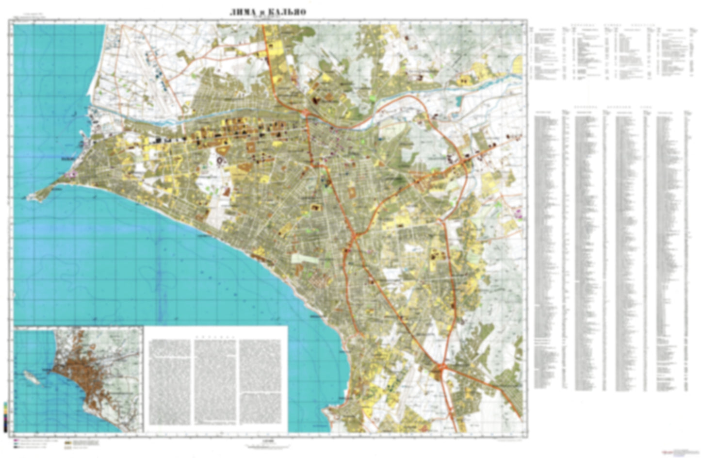
- During the Cold War and before easy access to high-resolution satellite imagery, The Soviet Military was secretly mapping the entire world. These aesthetically striking maps are beautiful down to the last detail and fantastic wall art and until now, have rarely been viewed or available to outsiders. This series has been covered by Wired Magazine and Greg Miller in his book, "All Over the Map: A Cartographic Odyssey". This map is part of the Soviet City Plans Series presented by East View, which has the largest collection of Soviet Military City Plans in the world. The Soviet Military City Plan(s) of Lima, Callao (Peru) is one in a series of highly detailed topographic city maps developed by the USSR Ministry of Defense during the Cold War era. These collectable, high resolution print-on-demand editions are delivered on premium, acid-free, matte paper. This item is sheet number 1 in a set of 1 sheet(s) for Lima, Callao Populated Places: Ascarrunz, Asesor, Ate, Bravo, Callao, Chavarria, Coronel, Egle, El Agustino, Encalada, La Basilia, La Milla, La Palma, La Taboada, Manzanilla, Maranga, Matasango, Palomares, Quiroz, San Juan, San Juan de Lurigancho, Santa Rosita, Santoyo, Tebes, Villegas Military and Defense: Base Naval del Callao, Comandancia General de la Marina, Las Palmas Parks and Reservations: Parque de Las Leyendas, Parque La Pera del Amor, Parque la Redonda Landmarks and Natural Features: Cerro Agustino, Cerro Atilio, Cerro Centinela, Cerro El Chivo, Cerro Lurigancho, Cerro Mina, Cerro Monterrico, Cerro Pamplona, Cerro San Cristobal, Cerro Segundo, Cerro Verdes, Cerros de Camacho, Cerros de San Francisco, Cerros Pedrero, Malecon Cisneros, Malecon La Marina, Playa Agua Dulce, Playa Arenilla, Playa Barranco, Playa Cantolao, Playa Carpayo, Playa Cascadas, Playa Estrella, Playa La Herradura, Playa La Pampilla Water Bodies: Bahia del Callao, Ensenada de Chorrillos, Gran Bahia de Lima, Mar Brava
- Subtype: City Plan
- Language: Russian
- Publication Date: 1980-06-01
- Scale: 1:25,000
- Countries Covered: Peru
- MPN: LIMA,CALLAO
- Folded Size: N/A
- Unfolded Size: 54.2" (W) x 35.4" (H)
- Weight: 4.8 oz