Tom Patterson Maps
Kalaupapa National Historical Park - Laminated
Kalaupapa National Historical Park - Laminated
Regular price
$26.00 USD
Regular price
Sale price
$26.00 USD
Unit price
per
Shipping calculated at checkout.
Couldn't load pickup availability
- SKU: PODTP_KALAUPAPA_LAM
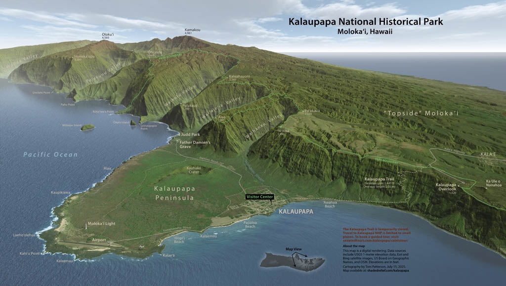
- Located on the north shore of Molokai, Hawaii, this park on an isolated peninsula was once a large leper colony. A handful of patients still remain. Visitor access is only by trail down a steep escarpment. Just beyond the Kalaupapa Peninsula, the highest sea cliffs on Earth rise over 3,000 feet (900 meters) above the Pacific. This photo-realistic 3D map created from digital data captures the magnificent setting. Elevations and distances are in feet and miles. Gloss Laminated Paper (Durable, High-Impact Finish) This option begins with our standard matte paper and is finished with a professional gloss laminate. The lamination enhances color vibrancy and contrast while adding durability and moisture resistance. The glossy surface is easy to wipe clean and helps protect the map from handling, making it ideal for long-term use. Best for: Classrooms, public spaces, field use, planning environments, and high-traffic areas.
- Subtype: Wall Art
- Language: English
- Folded Size: N/A
- Unfolded Size: 31" (W) x 18" (H)