Tom Patterson Maps
High Mountain Asia - Physical Features - Laminated
High Mountain Asia - Physical Features - Laminated
Regular price
$30.00 USD
Regular price
Sale price
$30.00 USD
Unit price
per
Shipping calculated at checkout.
Couldn't load pickup availability
- SKU: PODTP_HMA_PHY_LAM
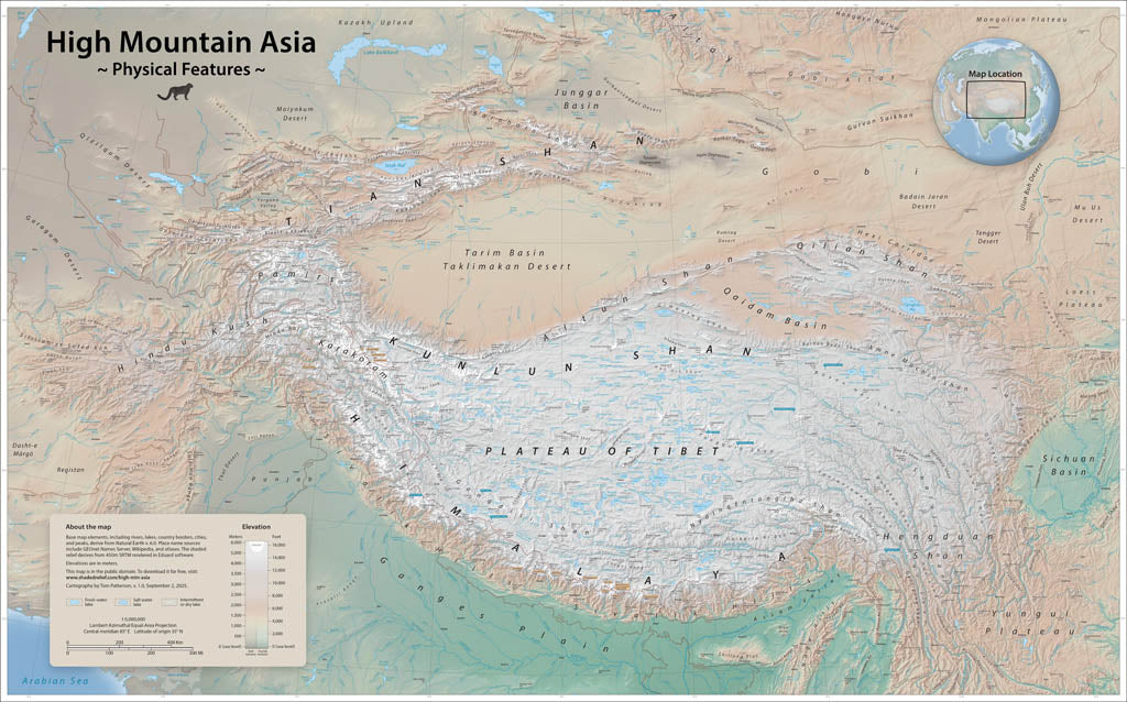
- This is Earth’s loftiest region, formed by the Indian tectonic plate sliding northward beneath the Eurasian plate. It contains the largest reservoir of glacial ice outside of polar regions. Meltwaters from the glaciers feed rivers that nearly 3 billion people in adjacent lowlands depend on for drinking water and crop irrigation. This wall map depicts elevations with cross-blended hypsometric tints and shaded relief. Call-out boxes indicate the fourteen 8,000-meter peaks and the sources of major rivers. Elevations are in meters. Gloss Laminated Paper (Durable, High-Impact Finish) This option begins with our standard matte paper and is finished with a professional gloss laminate. The lamination enhances color vibrancy and contrast while adding durability and moisture resistance. The glossy surface is easy to wipe clean and helps protect the map from handling, making it ideal for long-term use. Best for: Classrooms, public spaces, field use, planning environments, and high-traffic areas.
- Subtype: Wall Art
- Language: English
- Scale: 1:5000000
- Folded Size: N/A
- Unfolded Size: 47" (W) x 30" (H)