USSR Ministry of Defense
Boston, MA 1 (USA) - Soviet Military City Plans
Boston, MA 1 (USA) - Soviet Military City Plans
Regular price
$49.95 USD
Regular price
Sale price
$49.95 USD
Unit price
per
Shipping calculated at checkout.
Couldn't load pickup availability
- SKU: SUAA-BOSTON1-P
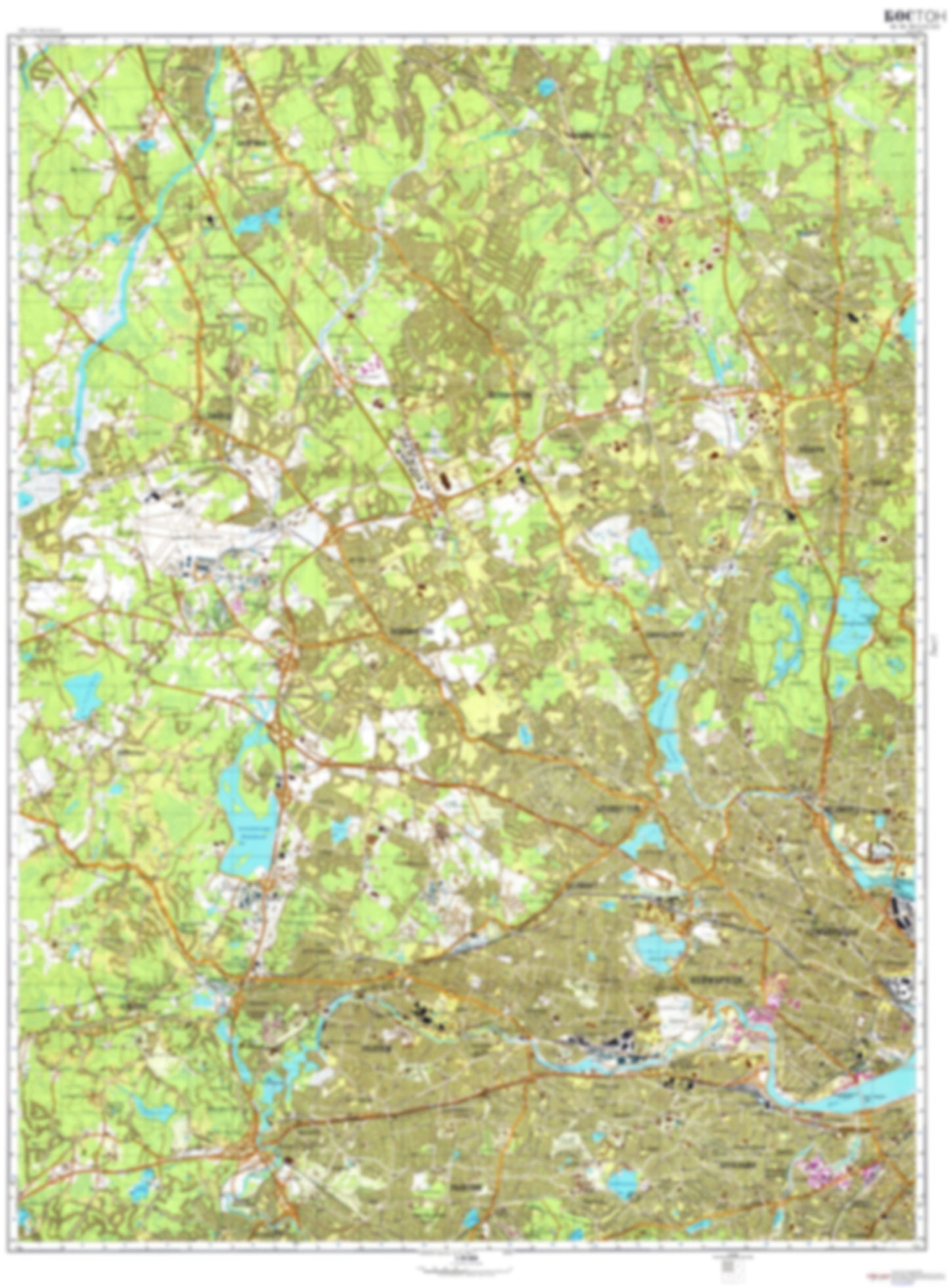
- During the Cold War and before easy access to high-resolution satellite imagery, The Soviet Military was secretly mapping the entire world. These aesthetically striking maps are beautiful down to the last detail and fantastic wall art and until now, have rarely been viewed or available to outsiders. This series has been covered by Wired Magazine and Greg Miller in his book, "All Over the Map: A Cartographic Odyssey". This map is part of the Soviet City Plans Series presented by East View, which has the largest collection of Soviet Military City Plans in the world. The Soviet Military City Plan(s) of Boston, MA 1 (USA) is one in a series of highly detailed topographic city maps developed by the USSR Ministry of Defense during the Cold War era. These collectable, high resolution print-on-demand editions are delivered on premium, acid-free, matte paper. This item is sheet number 1 in a set of 4 sheet(s) for Boston, MA Populated Places: City of Cambridge, City of Medford, City of Newton, City of Somerville, City of Waltham, City of Watertown Town, City of Woburn, Town of Arlington, Town of Bedford, Town of Belmont, Town of Billerica, Town of Burlington, Town of Lexington, Town of Lincoln, Town of Reading, Town of Stoneham, Town of Weston, Town of Wilmington, Town of Winchester Military and Defense: Hanscom Air Force Base Parks and Reservations: Bedford Levels, Parker Meadow Landmarks and Natural Features: Andrews Hill, Arlington Heights Hills, Aspinwall Hill, Babylon Hill (historical), Balls Hill, Bannon Hill, Beacon Hill, Bear Hill, Bear Hill, Bear Hill, Belfry Hill, Blueberry Mountain, Boojum Rock, Bucks Hill, Buttricks Hill, Carters Hill, Cat Rock Hill, Cedar Hill, Chestnut Hill, Clarendon Hill, College Hill, Coolidge Hill, Corey Hill, Cowdry Hill, Cranberry Hill Water Bodies: Arlington Reservoir, Back Bay Fens, Blacks Nook, Brookline Reservoir, Cambridge Reservoir, Charles River Reservoir, Crystal Lake, Fisher Hill Reservoir, Halecyon Lake, Lexington Reservoir, Lincoln Reservoir, Lower Mystic Lake, Middle Reservoir, Mishawum Lake, Mystic Lakes, Newton Reservoir, North Reservoir, Nutting Lake, Payson Park Reservoir, Silver Lake, South Reservoir, Storrow Lagoon, Waban Hill Reservoir, Weston Reservoir, Woburn Reservoir
- Type: Map
- Subtype: City Plan
- Language: Russian
- Publication Date: 1979-06-01
- Scale: 1:25,000
- Regions Covered: Mid-Atlantic/Northeastern U.S., North America
- Countries Covered: United States
- States Covered: Massachusetts
- MPN: BOSTON1
- Folded Size: N/A
- Unfolded Size: 35" (W) x 47.5" (H)
- Weight: 4.8 oz