USSR Ministry of Defense
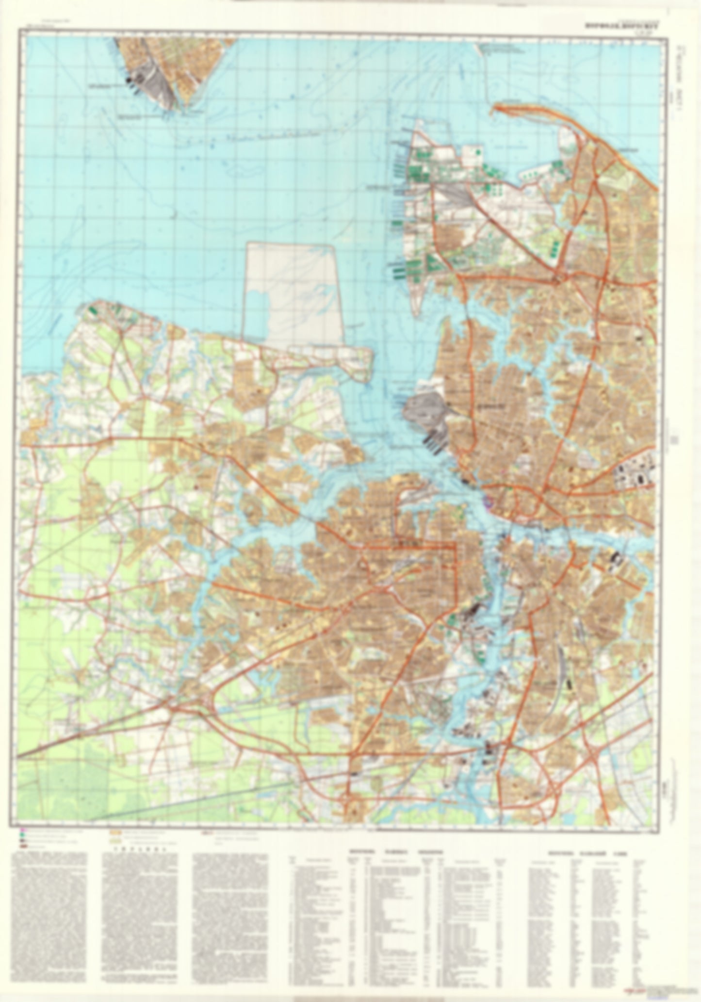
Norfolk, Portsmouth, VA 1 (USA) - Soviet Military City Plans
Norfolk, Portsmouth, VA 1 (USA) - Soviet Military City Plans
Regular price
$49.95 USD
Regular price
Sale price
$49.95 USD
Unit price
per
Shipping calculated at checkout.
Couldn't load pickup availability
- SKU: SUAA-NORFOLK1-P
- During the Cold War and before easy access to high-resolution satellite imagery, The Soviet Military was secretly mapping the entire world. These aesthetically striking maps are beautiful down to the last detail and fantastic wall art and until now, have rarely been viewed or available to outsiders. This series has been covered by Wired Magazine and Greg Miller in his book, "All Over the Map: A Cartographic Odyssey". This map is part of the Soviet City Plans Series presented by East View, which has the largest collection of Soviet Military City Plans in the world. The Soviet Military City Plan(s) of Norfolk, Portsmouth, VA 1 (USA) is one in a series of highly detailed topographic city maps developed by the USSR Ministry of Defense during the Cold War era. These collectable, high resolution print-on-demand editions are delivered on premium, acid-free, matte paper. This item is sheet number 1 in a set of 2 sheet(s) for Norfolk, Portsmouth, VA Populated Places: City of Portsmouth, South Norfolk Borough, Western Branch Borough Military and Defense: Coast Guard Station Portsmouth, Craney Island Fuel Depot, Naval Medical Center Portsmouth, Naval Shipyard Norfolk, Naval Station Norfolk, Naval Station Norfolk Saint Juliens Creek Annex, Naval Support Activity Norfolk Parks and Reservations: Ludlow Flats Landmarks and Natural Features: Big Point, Charters Island, Craney Island, Drum Point, Hatton Point, Hospital Point, Knotts Neck, Lamberts Point, Lawless Point, Lovett Point, Money Point, Newport News Point, Pinner Point, Sewells Point, Tanner Point, Town Point, Washington Point, Willoughby Beach, Willoughby Spit, Windsor Point Water Bodies: Craney Island Reach, Edgewater Haven, Entrance Reach, Green Lake, Hampton Roads, Horseshoe Lake, Lake Cavalier, Lake Collins, Lake Forest, Lake Jean, Lake Kingman, Lake Pam, Lower Reach, Mathews Lake, Middle Reach, Newport News Channel, Port Norfolk Reach, Town Point Reach, Upper Reach, Willoughby Bay
- Subtype: City Plan
- Language: Russian
- Publication Date: 1975-06-01
- Scale: 1:25,000
- Countries Covered: United States
- MPN: NORFOLK1
- Folded Size: N/A
- Unfolded Size: 36.5" (W) x 52.2" (H)
- Weight: 4.8 oz